SPAR@MEP aims to derive a consistent SPOT-VEGETATION and PROBA-V Aerosol and Surface Reflectance long-term data record in the PROBA-V Mission Exploitation Platform (MEP). The projects deliverables will consist on a Long Term Regional Data Record of Aerosol Optical Thickness (AOT) and Bidirectional Reflectance Factor(BRF) at 1Km of resolution over Europe for year 2019 and on a global processing of the entire Vegetation/PROBA-V archive at a spatial resolution of 5km. The target processing facility will be the Proba-V MEP. The radiometric accuracy and multi-temporal stability of the considered long-term data record, which was acquired with three different radiometers (SPOT-4, SPOT-5 and Proba-V), should be carefully assessed as a first verification step for the project. Furthermore, the processing performances should be significantly improved in order to sustain the mission reprocessing. To this end, the current plan is to exploit multi-cores CPU, or, alternatively, the GPU technology. Both parallel processing with CPU multi-cores and GPU servers are available on the MEP to support this project.
The comprehensive PV-LAC feasibility study demonstrated the possibility to apply the CISAR algorithm on PROBA-V data for the joint retrieval of surface reflectance and aerosol optical properties. On top of that, under the conxtext of the CIRCAS study the CISAR algorithm has been modified to also retrieve cloud optical thickness and can therefore can be run without the need of an external cloud mask.
Govaerts, Y. and Luffarelli, M. (2018) “Joint retrieval of surface reflectance and aerosol properties with continuous variations of the state variables in the solution space: Part 1: theoretical concept”, Atmospheric Measurement Techniques, 11, no. 12, 6589–6603.
Luffarelli, M. and Y. Govaerts. (2019). “Joint Retrieval of Surface Reflectance and Aerosol Properties with Continuous Variation of the State Variables in the Solution Space – Part 2: Application to Geostationary and Polar-Orbiting Satellite Observations.” Atmospheric Measurement Techniques 12 (2): 791–809.
Within the SPAR@MEP project, 1 year of PROBA-V observations has been processed globally at 5 km resolution with the CISAR algorithm. CISAR has been shipped to the VITO Mission Explotation Platform (MEP) together with its General Data Processing Chain (GEDAP) as a Docker image to reduce all possible compatibility issues. A Dask scheduler optimised the distribution of the processing across the MEP, making the most of the platform developed by VITO. The final products include the Aerosol Optical Thickness (AOT) at 550 nm and in each processed band, together with the associated fine mode fraction, and the surface reflectance free from any atmospheric contribution in all processed bands, expressed in terms of BiHemispherical Reflectance (BHR). The video below shows the daily AOT at 550 nm obtained by CISAR. The AOT product shows the capability of CISAR to retrieve seasonal and regional patterns such as the higher occurrence of dust storm in the Sahara region in spring, the biomass burning season in Central Africa during the summer, the high pollution in India and China, and the fire season in Australia.
Zoomming on North Africa, it possible to appreciate the retrieval of the dust season starting from March, with dust storms moving towards Europe.
Looking at the BHR in the same region, the stability of the surface retrieval in the BLUE band is remarkable. Similar stability is observed in all bands to the exception of the SWIR. The reason for this difference is to be found in the characterisation of the radiometric uncertainty; in the SWIR, the relative gain among the detectors shows larger residuals compared to the other bands, which cause the visible stripes in PROBA-V SWIR images. This effect varies with the brightness of the targets: due to this non-linearity, characterising and correcting this effect is not straightforward. More information on PROBA-V radiometric characterisation can be found here.
| . | . |
|---|---|
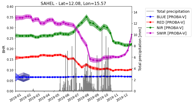
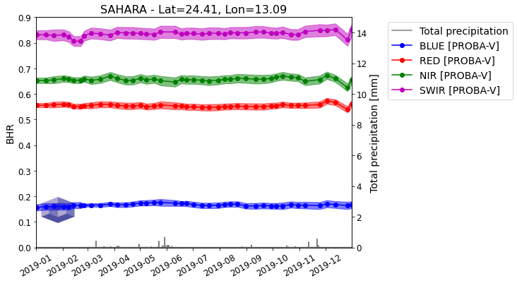
From the video above, it is also possible to observe the seasonal expansion and retrogration of the region of the Sahel following the rainy season. The timeseries below show the BHR retrieved by CISAR in the four PROBA-V bands over two pixels located in the Sahel and Sahara regions respectively. The shaded area represents the retrieval uncertainty and the black line represents the total precipitation. While the retrieval over the Sahara is very stable, as expected given the high stability of the desert reflectance at the processed resolution, the surface reflectance over Sahel shows a strong seasonal variation following the rainy season starting in May.


The Global Products can be downloaded on the Zenodo repository (BHR, AOT ) together with the associated Product Specification Document (PSD). A scientific publication will be prepared to advertise the SPAR@MEP project’s results and achievements.
The Final Review (FR) took place at ESRIN, Frascati, on the 7th of December. The project achievements have been summarised and presented (20 years LTDR consistency, combined aerosol/surface retrieval at 1km over Europe and at 5 km globally). Final results on the Global Dataset (GD) at 5km have been presented. The GD products are available on the Zenodo repository at the following links:
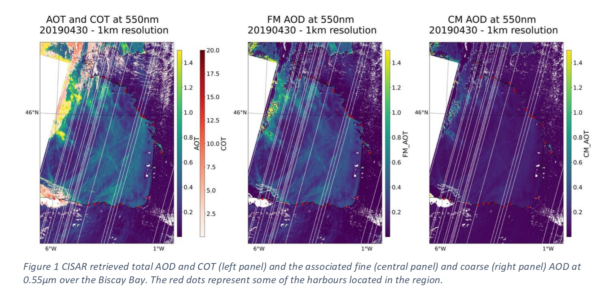
A webstory has been published on ESA website on the aerosol retrieval from PROBA-V observations in the framework of the SPAR@MEP project. The webstory focuses on the retrieval of ship trails from PROBA-V images at 1km resolution with the CISAR algorithm. This interesting case study demonstrates the capability of the CISAR algorithm to correctly differentiate between fine and coarse mode. Also, processing both aerosols and clouds, the CISAR algorithm could represent a powerful tool to study aerosol-cloud interactions, such as the Twomey effect, using high resolution satellite imagery. The webstory can be found at: https://earth.esa.int/eogateway/news/ship-trails-in-the-bay-of-biscay-observed-using-proba-v-imagery.

The Mid-Term Review (MTR) took place virtually via Webex on the 29th of September. First results of the LTRDR have been presented, obtained with the latest version of the CISAR algorithm, which includes the processing of cloudy pixels. A webstory will be published to advertise these results. The project duration has been extended by 6 months.
The second progress meeting took place virtually on the 26th of May 2020. During the meeting the results on the calibration study on PROBA-V performed by Rayference have been presented, and they will be shown at the next PROBA-V Quality Working Group. The date of the Mid-Term Review has been fixed to September 29th.
A technical meeting between Rayference and VITO took place at VITO premises on the 23rd of January 2020. During this meeting, the technical aspects of GEDAP implementation in the MEP have been discussed, together with the necessery resources to allocate for the project.
The first progress meeting took place in Brussels on the 22/01/2020. The first milestone was successful with the deliverable of the surface reflectance dataset. During PM1, it has been decided to generate the Long-Term Regional Data Record (LTRDR) over Europe at 1 km resolution and the Global Dataset at 5 km resolution for the full Vegetation-PROBA-V archive. The next progress meeting will take place on the 26th of May 2020.
The SPAR@MEP kick-off meeting took at ESRIN (IT) on the 06/09/2019.